Tuesday, May 29, 2007

Waddington Bay


May 29, 2007
Time: 0815
Hrs: 743 Log: 2717 nm
Lv: Waddington Bay
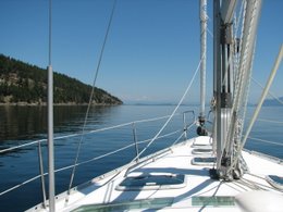
Course: Retreat Passage > Queen Charlotte Strait > Alert Bay > Broughton Strait > Queen Charlotte Strait > Port Hardy

Nothing, not even a single hermit crab in the trap this morning! We are heading across Queen Charlotte Straight to Alert Bay. We are on killer whale watch. Surprisingly we saw a log floating in Blackfish Sound with a seal and an eagle on it. The seas are almost like glass this morning, it is soooo beautiful here.
Arv: Alert Bay, Cormorant Island
Time: 1200
We are just stopping for a look around this pretty village. The lady at the Tourist Information Centre said that the killer whales have not arrived in the area yet. She didn’t know where they come from, only that they are not here. So, I guess we won’t see any whales today.
Arv: Port Hardy
Lat: 50 42.47 N
Lon: 127 29.22 W
Time: 1900
Trip: 41.1 nm

Cruising to the Broughtons

This is soooo cool!! I don't know why the dolphins like to swim along side boats, but maybe because it is just fun?!? Who knows?
May 28, 2007
Time 1000
Log: 2710 Hrs: 738
Lv: Laura Cove
Course: Cramer Passage > Retreat Passage > Waddington Bay
Nothing in the crab trap this morning but a small male rock crab and a hermit crab. We are going to motor around the Broughton Islands today, do some trolling and then find a nice anchorage. A small school of Pacific White Sided Dolphins swam around our boat for a few minutes as we were trolling along.
Arv: Waddington Bay, Bonwick Island, Broughton Archipeglago
Lat: 50 43.100 N
Lon: 126 36.813 W
Time: 1400
Trip: 8.0 nm
We are the only boat (it seems) in The Broughtons. It is so quiet, we can hear the noise the barnacles are making as the tide comes back in.

Lacy Falls, Tribune Channel


May 27, 2007
Time: 0910
Log: 2666 nm Hrs: 731
Lv: Port Harvey
Course: Havannah Channel > Chatham Narrows > Knight Inlet > Nickoll Passage > Tribune Channel > Laura Bay, Broughton Island
Caught 4 red rock crab in the trap, all a very nice size but all were very female too! Today is the day Vincent and Noelle leave for Thailand. We are thinking of them and hoping they have a good flight. When we get closer to Port Hardy, we will be able to post on the blog and I am hoping to have an email from him about his flight. We are on our way up Chatham Channel, heading towards Minstrel Island. Our plan today is to anchor in the Broughton Islands and then depending on the weather, maybe do some kayaking tomorrow. We enter Knight Inlet, put up the head sail and just fly across at 7.5 knots! Beautiful sailing with 20 knots of wind on our tail.
Arv: Laura Cove
Lat 50 49.43N
Lon126 34.06W
Time: 1900
Trip: 44.5 nm

Looking towards Vancouver Island


May 26, 2007
Time: 0725
Log: 2651 Hrs: 726
Lv: Blenkinsop Bay
Course: Johnstone Strait > Port Harvey Harbour

We are taking a short hop up Johnstone Straight early this morning because the forecast is for winds 15 to 25 knots this afternoon. Put the crab trap down in 150’ in Port Harvey.
Arv: Port Harvey
Time: 1050
Lat: 50 33.34N
Lon: 126 16.18W
Trip: 14nm
Really nice quiet anchorage on the east side of the inlet. The wind is picking up in out in the straight but we don’t get much where we are. We fixed lunch and headed out in the tender to explore around the harbour. I put out the trolling line, but didn’t catch anything.

Shoal Bay


May 25, 2007
Time 1050
Log: 2628 nm Hrs: 722
Lv: Shoal Bay, East Thurlow Island
Course: Cordero Channel > Chancellor Channel > Wellbore Channel > Sunderland Channel > Johnstone Strait > Blenkinsop Bay

We took the tender over to the dock and walked around some old historic buildings. This was a nice quiet anchorage. We stopped to pick up the trap again, and only had 3. Hummm, this is going to take awhile to get enough for dinner! We are motoring as there is no wind again. We timed our departure to take advantage of slack water in Green Point Rapids in Cordero Channel. The winds picked up enough to sail as we turned to head through Wellbore Channel.
Arv: Blenkinsop Bay
Lat 50 28.86 N
Lon 126 00.84 W
Time: 1730


Octopus Islands Marine Park


May 24, 2007
Time 1050
Log: 2612 nm Hrs: 715
Lv: Octopus Islands Marine Park
Course: Hoskyn Channel > Hole in the Wall > Calm Channel > Cordero Channel

We stop to pick up our prawn trap that we put down in 250’ the day before. We are hopeful, but not too successful…. only 4 prawns. We have timed our departure so that we can get through Hole-in-the-wall. We want to go through close to slack because the currents can reach 12 knots when the tide is running as full strength. We exit the other side into Calm Channel, between Stuart Island and Sonora Island. I tried to do some fishing through Hole-in-the-wall, but all I caught was seaweed again.
No sailing today, just motoring. Had a good run through Yuculta Rapids, then stopped in Big Bay on Stuart Island for a short hike and wait for the tide to turn to slack so we could go through Dent Rapids. We saw a few Dall’s Porpoise and a bunch of Steller Sea Lions just west of Dent Rapids. Put our prawn trap out again in 250’ just outside Shoal Bay.
Arv: Shoal Bay, E Thurlow Island
Lat: 50 27.693 N
Lon: 125 21.848 W
Time 1910

Wednesday, May 23, 2007

Rebecca Spit


After dinner last night we rode our bikes over to Rebecca Spit, it was such a beautiful evening. The scenery on the spit is really breath taking, pictures do not do it justice.
Our internet service will become more and more sketchy from this point on so I will not be able to blog as much.
May 23, 2006
Time: 0830
Lv: Heriot Bay
Course: Strait of Georgia > Hoskyn Channel > Octopus Islands M. P., Quadra Island
Our plan for today is to anchor at the north end of Quadra in
Octopus Islands Marine Park. The weather forecast is for light winds from the SE, but not enough to sail. We motored out a little way from Heriot Bay where we had an internet connection. Jerrry did a little stock trading while I tried some jigging. Caught some seaweed, but that was all. Our route took us up Hoskyn Channel between Quadra and Read Island. The most excitement we had was going through Surge Narrows…. Our instruments told us we were doing 11.8 knots SOG (speed over ground). That is the fastest we’ve had our boat going.
We arrive just outside
Octopus Islands and put our prawn trap out in 250’.
Arv: Octopus Islands Marine Park
Lat 50 16.66 N
Lon 125 13.97 W
Time: 1445
Distance: 10 nm

Heriot Bay Marina


This is the dock at the Heriot Bay Inn, does anyone recognize this place? We stayed two nights here, cell phone service is non-existent but they have their own sloooow wireless internet that we have been able to log on to for a few minutes at a time. Yesterday we rode our bikes across the island, and got on the ferry to Campbell River. We had decided we needed to buy some boat boots, it had been an item on our list but one we did not get around to buying. We were successful, and we also took the opportunity to get a blizzard at DQ since it may be a long time before the next one.

Monday, May 21, 2007

Aww, pooor Charles...

May 21, 2007
Time: 1030
Log: 2563 nm
Lv: Comox Harbour
Course: Comox Harbour > Strait of Georgia > Heriot Bay, Quadra Island
Arv: Heriot Bay, Quadra Island
Lat 50 06.19 N
Lon 125 12.70 W
Time: 1900
We left Comox Harbour this morning, the sky beautiful and clear! Our winds were a blustery 11 knots, but we had 4' swells, some crashing over our bow. This did not go over very well with HRH Prince Charles. It was his first day of being seasick. These swells formed yesterday and over night as the winds changed direction from the SE to NW. But the good news is that the swells have calmed down now, Charles is sleeping in the bright sunshine and feeling much better. We plan to arrive in Heriot Bay on Quadra Island and maybe meet up with Susan Wilson, our B & B host for our 'Girls Getaway Weekend' last fall. I have sent her an email, we'll see if she gets it in time.

Sunday, May 20, 2007

HAPPY BIRTHDAY DAVID


I almost forgot! Today is my first born's 28th birthday. Happy Birthday David, I hope you are having a good birthday. Love you! Mom and Jerry

Next stop Comox

May 20, 2007
Time: 1130
Log: 2524.5 nm Hours: 698
Lv: Boho Bay
Course: Sabine Channel > Strait of Georgia > Comox Harbour
Arv: Comox Harbour
Lat49 40.11 N
Lon 124 55.98 W

We had a really crazy night last night in Boho Bay. The wind was howling at up to 27 knots from the SE. We were expecting wind from the NW ( from the weather report on the radio), so consequently we took all night. Our anchorage had three other boats, they must all have been thinking the same thing. But between the wind and Charles (he was going from one window to another because he didn't like the wind either) Jerry and I got very little sleep. Our anchor held just fine though, and in the morning it was relatively calm. We had breakfast and got under way. The picture above is us dressed very warmly (and safely) in our new survival suits. If we happen to fall overboard with this suit on, we will float (it is like a PFD) and they are suppose to keep you relatively warm for up to two hours.
We are sailing across Georgia Straight right now, heading for Comox. Tonight's wind is suppose to come from the NW, so we'll see. Charles is sleeping. :-)

Ready to set sail.


May 19, 2007
Time: 1205
Log: 2501 Hours 697
Lv: Nanaimo Harbour
Course: Newcastle Passage > Strait of Georgia >Sabine Channel > Boho Island
Ar: Boho Bay, near Boho Island
lat 49 29.80N
lon 124 13.90W
Trip: 18.9nm

We had a slow start out of Nanaimo Harbour because we decided we needed a few items from the store before we left. Rick Stanley, our house sitter and good friend, was kind enough to stop by and meet us with some forgotten items and then he drove us to the Chandlery. The last item on our list was an American flag. When sailing in international waters, it is customary to fly the flag of the nation whose waters you are in. The flag we bought is called a courtesy flag and we will put it up when we enter Alaskan water.
The picture above is showing Jerry at the helm, but you can see behind him that we strapped our tender to the stern so that it wouldn't slow us down while we were sailing. So far it is working very well.
Since most people viewing this blog are not boat people, you may not know the definitions of all the 'boat' words I have been using. By the time we get home, everyone will know the meaning of a boom, tack, gib, port, etc. I am not going to tell you, it is up to you to figure it out!
Cheers!

Saturday, May 19, 2007

Charles's first day.

Date: May 18, 2007
Time: 1520
Leave: Ladysmith
Log: 2486 nm Hours: 694
Course: Ladysmith Harbour > Stuart Channel > Dodds Narrows > Nanaimo Harbour
Arrive: Nanaimo Harbour
Lat 49 10.265N
Long 123 56.413W
Trip: 15.4 nm

This is how Prince Charles spent his afternoon on his way to Nanaimo. His Royal Highness is cuddled up in his new 'cat' bed and covered by his favorite blanket.
We had an uneventful day until we started heading through Dodd Narrows. Just when we were at the most narrow part, a big 45 foot powerboat (American!) blows by us like we were standing still, even though we were doing a respectable 7 knots. The a___hole has a bow wave the almost the height of our boat and gave us a good rocking. Funny thing though, they didn't think they were doing anything wrong as they gave us a friendly wave when passing while we were trying to stay on course and not hit the rock wall!
Until next post... Cheers!

Tuesday, May 15, 2007

Aboard Splendid Mane


Vincent's first time on Splendid Mane... Amy, David, Ella and Vincent came to visit us 10 days ago, and we took them out for a sail. We were lucky to have beautiful sailing weather and winds up to 17 knots.
Today, we have been spending most of the day doing last minute prep on the boat. Jerry changed the oil and I went grocery shopping. Our departure day has been moved up to Friday May 18th. We will leave in the afternoon and catch the slack tide going through Dodd Narrows and then anchor in Nanaimo Harbour.
Ella checks out the companionway.

Sunday, May 13, 2007

Going up........


This is Kathy up near the top of the mast. I am sitting in a 'bosun's chair', about 40 feet above the water, that Jerry pulled up the mast with me in it (no easy feat!). I had to move our radar reflector higher on the mast as well as take the wind indicator off the tippy top of the mast, get Jerry to fix it, and then reattach it. This is one of the really fun parts of having a sailboat!

Saturday, May 12, 2007

Old Prop, New Prop


One job we wanted to do while the boat was out of the water was to replace the propeller. The top picture is of our old prop and the bottom picture is the new prop. What is special about this prop is that it is a 'feathering' prop. When the boat is sailing, the blades turn sideways so that they 'slice' through the water instead of pushing through. This gives less drag and therefore more speed while sailing, up to 1.5 knots per hour. That may sound like a small amount, but when you add that up over an eight hour day of sailing, it can be significant, and mean the difference between having happy hour or just going to bed when you get to your anchorage (right Walter and Mavis?)

Friday, May 11, 2007

The Haul Out


Part of the process of getting Splendid Mane ready to sail is to have the bottom repainted. This process has to be done at least every two years. The bottom of a boat has a special paint on it to prevent sea life (barnacles, muscles, plants, etc.) from growing on it. This paint wears off after two years, so it has to be re-applied. It is also a good time to have a look at the underside of your boat to make sure everything is okay.
This year, we hauled out at the end of March in Maple Bay BC. The crane lifting our boat can lift a boat a lot heavier than ours, but not wider. There was only inches between the side of our boat and the crane.
Once out of the water and on dry land, they pressure washed the bottom and then applied the paint. Splendid Mane was only out of the water for 24 hours. Tomorrow I will tell you what else we did to our boat when it was out of the water.

Monday, May 7, 2007

Splendid Mane... the details.


Our sailboat is made by Beneteau, a French boat manufacturer, but was built in South Carolina USA. It is 40' long and 13' at it's widest point (called the beam). It has a draft of 5'1", which means we can go in water that is 6' deep without touching the bottom (but we wouldn't do that because we might hit a rock). It weighs about 17,000 pounds empty. We have the two cabin version of boat, but it is also available in a three cabin. If you want to see more, you can follow this link...... Beneteau 393 Sailboat
The picture above is of our sailboat sitting at our dock in Ladysmith Harbour next to the Marissa Ann, our friend's sailboat.