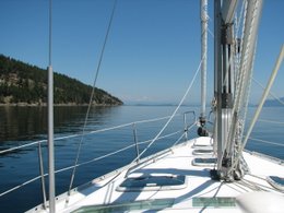
These are pictures I have taken along the way and I have created a little guessing game, but only for those of you who really don't know sailboats that well. There are some easy ones, but others you might have to do some research. Starting with the picture at the top left and working your way through like reading a book, which picture goes with....
1 halyards
2 helm
3 hatch
4 boom
5 bow
6 winch
7 captain
8 radar
9 mast
10 dodger
11 flag
12 gimbled cooking device
13 life lines
14 spreader
15 gimbled lamp
16 main sail
Have fun!
Wednesday, June 27, 2007


Tuesday, June 26, 2007

 The stairs on the trail to Mendanhall Glacier and at the library in Juneau.
June 25 and 26
Two days for exploring
Tomorrow we will be leaving and heading west towards Chichagof and
Incredible colour

These pictures hardly do them justice, you really have to see this for yourself to appreciate the deep colour in the ice.

More Ice Berg Pictures
 This one has tipped over on it's side. You can see how it was originally sitting in the water by the flat area. That part would have been on the surface with the rest below the water.
A cold perch

June 24, 2007
Time: 0715 Hrs: 888.0
Humidity 67% Temp: 10 C Overcast, light rain, calm winds
Lv:
Course: Stephens Passage >
We were debating skipping
Arv: Auke (pronounced “oak”) Bay Marina
Lat: 58 22.95 N
Lon: 134 38.96 W
Time: 1715
Trip: 50.2 nm Log: 3439.1 nm
Fill with diesel: 22.6 Gal $73.82 US
This is a nice marina a little outside
Monday, June 25, 2007
Iceberg Animal

We were having fun looking at the shapes of the bergs....... what does this one look like?
South Sawyer Glacier, from 2 miles away.


June 23, 2007
Time: 0600
Humidity: 66% Temp: 9 C Overcast, calm winds.
Today we are making a round trip up Tracy Arm and back to this anchorage. We are hoping to see the glaciers that are producing all the icebergs. The trip to Sawyer Glacier is about 21 miles. Two small cruise ships are in the first leg of the arm with us, but they can’t go in far. Half way through, the icebergs start to get bigger and more plentiful. We have to reduce our speed to almost an idle. Traveling up through Tracy Arm is like going back through geologic history. The walls of the fjord start to loose their vegetation the further in you go, until they become smooth, bare rock, shaped and ground by the ice. In some places the water is over 1000 feet deep, and with mountains towering vertically above us you sense the awesome power of the glacier many thousands of years ago. We meet another small tour boat coming back (with cruise ship passengers), so we radio him to find out how far we are going to be able to go. He tells us forget about South Sawyer Glacier but we can get to North Glacier, with difficulty. We decide to get within sight of both, stop for some lunch and then head back. With our engine quiet now, we can hear the sounds of the ice breaking, water falling down the steep canyon walls and the young seal pups on the ice calling to their mothers. We are the only humans here for the time being. Our solitude is broken by the sound of another tour boat coming, time to head back. I steer while Jerry stays on the bow with a boat hook, trying to push the bergs as we plow through. It is a sight worth filming….. another tour boat passes us with the passengers madly clicking cameras and video!
Arv: Back at
Time: 1645
We stopped to net some more glacier ice to enjoy Glenfiddich back at anchor.


Baranoff Island from 55 miles away

June 22, 2007
Time: 0830 Hrs: 872.6
Humidity 63% Temp: 15 C Another gorgeous day in
Lv:
Course: Stephens Passage >
This picture is taken as we cruised up Stephens Passage looking across at Baranoff Island, about 55 miles away! Charles is starting to be a little braver everyday. He came out into the cockpit on his own this morning to get a little sun. I think he is starting to enjoy himself! More humpbacks sighted, but of course they are miles away.
Arv:
Lat: 57 48.66 N
Lon: 133 38.08 W
Time: 1450
Trip: 23.8 nm Log: 3354.9 nm
We get our first look at icebergs! They are so beautiful up close. After putting down the anchor, we quickly get the dingy off the boat and head out to get some pictures and ice. We have another present to open tonight from Walter and Mavis. Of course we have a pretty good idea what it is since it is suppose to be mixed with glacial ice from Tracy Arm!
Touring around Hobart Bay

June 21, 2007
Time: 0915 Hrs: 864.4
Humidity: 57% Temp: 17 C Partly cloudy.
Lv: Petersburg
Course:
The wind is calm but we are hoping to pick up a little when we enter Stephens Passage. As we turn the corner past
Arv:
Lat: 57 24.16 N
Lon: 133 26.42 W
Time: 1600
Trip: 38.0 nm Log: 3331.1 nm
This is in cozy little anchorage with a small public dock. We are the only ones when we tie up, but later a fishing boat anchors nearby and then another sailboat ties up behind us. They are from
Bicycling in Petersburg

June 20, 2007 We are going to stay in
Tuesday, June 19, 2007
Our favorite dinner....

I couldn't resist showing you our wonderful salmon dinner. And BTW...... HAPPY BIRTHDAY MARGIE!
Wrangell Narrows

June 19, 2007
Time: 0750
Humidity: 72% Temp: 13 C Partly cloudy, calm. Forecast is for maybe some rain.
Lv:
We have to time our departure so that we get to Green Point in
Arv: Petersburg
Lat: 56 48.79 N
Lon: 132 57.68 W
Trip: 30.6 nm Log: 3293.1 nm
We tied up at the dock and then had a quick look around town. We found out we could get internet service at the local library (where I am right now), so we hurried back to the boat, made our dinner of fresh caught sockeye salmon on the BBQ. We are going to stay here tomorrow and maybe do some kayaking.
Jerry driving the boat....

Wrangell Harbour fishing boats

June 18, 2007
Time: 0700 Hrs: 851.5
Humidity: 70% Temp: 13 C Partly Cloudy, calm.
Lv:
Course: Seward Passage > Zimovia Straight > Wrangell.
We can see some new snow on the mountain tops nearby and some blue sky ahead of us.
The water here is very muddy from the
Arv:
Lat: 56 27.87 N
Lon: 132 22.90 W
Time: 1400
Trip: 34.1 nm Log: 3262.5 nm
Purchase fuel: 23.2
We raft up with
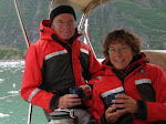
I have had a request for more pictures of ourselves, so here is another.......... (and yes Mom, we are still alive and well and on our boat!)

Our escort through Ernest Sound

June 17, 2007
Time: 0900 Hrs: 847.5
Humidity: 70% Temp: 15 C Overcast, winds 10-20 knots.
Lv: Meyers Chuck
Course:
We are following another boat whose occupants we met in Meyers Chuck, to the next anchorage in
On our way through
It started raining hard just before we head into
Arv:
Lat: 55 58.61 N
Lon: 131 55.99 W
Time 1345
Trip: 20.2 nm Log: 3228.4 nm
We let the engine cool for a few minutes and then Jerry changed the oil. That needs to be done about every 150 hours, so we may have to change it again before we get home. I finish up making a banana cream pie for Jerry for Father’s Day. He got pretty spoiled today I’ll tell you!

Meyers Chuck, after kayaking

June 16, 2007
Time: 0730 Hrs: 839.9
Humidity: 67% Temp: 18 C Sunny, no clouds, wind 10 knots
Lv:
Course:
The weather forecast is calling for moderate NW winds in the morning and then building to 25 – 35 knots for the afternoon. We did manage to get the sails up for a short time before we had to change course and head directly into the wind. For most of our trip, the wind has been coming straight towards us so we haven’t done as much ‘sailing’ as we would like. Close by our next stop we spot our first orca and then not too far away, we saw what looked like a humpback whale feeding close to shore. The orca was alone and just cruising by. Unfortunately, I did not get any pictures. But I am sure there will be other opportunities. That was pretty exciting, at least for me. Jerry doesn’t get as excited about this kind of stuff.
Contrary to the weather report, the wind died down to about 5 knots in the afternoon.
Arv: Meyers Chuck ( I love the name!)
Lat: 55 44.38 N
Lon: 132 15.48 W
Time: 1400
Trip: 29.4 nm Log: 3208.2 nm
This is a small community with a public dock. They have one telephone and a mail box and a gallery. Eight people live here full time, but the population grows to about 50 in the summer. The gallery had some very nice work from the locals. We bought Jerry a pair of hand knit wool socks and a very nice birthday card for Margie. Got the kayaks off the boat and had a little tour around the area. We saw a small black bear close to the water’s edge, but it took off before we could get very close. The winds picked up in Clarence Straight to about 30 knots and blew in a couple more boats. Splendid Mane is rocking a bit at the dock and we can hear the winds howling through the rigging. This is the kind of night we are glad to be in a protected harbour tied up to a dock rather than at anchor.
Friday, June 15, 2007
Ketchikan Alaska

June 15, 2007
Time: 0600 Hrs: 833.2
Humidity 74% Temp: 11 C Clear skies, light wind
Lv: Foggy Bay
Course: Revillagigedo Channel > Tongass Narrows > Ketchikan
Another nice day, I don't know what everyone is talking about when they say it rains here all the time. We have had some really beautiful weather.
Arv: Customs office, Ketchikan
Time: 1200
Cleared customs, very nice people. The way in to the harbour, just a little north of town, was very windy, up to 20 knots. But at the customs dock, it is well protected by the cruise ships sitting at their dock.
Arv: Bar Harbour Marina, Ketchikan
Lat: 55 20.99 N
Lon: 130 40.91 W
Time: 1400
Trip: 34.0 nm Log: 3178.8 nm
We took a walk around town, ooggled at the cruise ships, and all the tourists. I guess we are tourists too! It was fun, but too much going on around here. We will leave early tomorrow and go where we can have some peace and quiet again.
Alaska Day One, Foggy Bay

June 14, 2007
Time: 0845 Hrs: 830
Humidity: 70% Temp 15 C Sunny day, no clouds
Lv: Brundige Inlet
Course: Chatham Sound > Revillagigedo Channel > Foggy Bay, Misty Fiords National Monument, mainland Alaska
We are heading towards the US/Canada border, it is only a few miles to the north. I have been straining my eyes trying to see a whale or two, no luck so far. But we keep hearing they are around, so sooner or later we will run into one, I hope!
Arv: Foggy Bay, Alaska
Lat: 54 56.90 N
Lon: 130 56.35 W
Time: 1340
Trip: 23.2nm Log: 3144.8 nm
We put the sails up for a short time until the wind died down. But the seas were very choppy and it made a very uncomfortable trip, especially for HRH Charles. He got seasick again, but he is so good, he barfs in his litter box!
We are the first to anchor here for the day, but later 4 other boats come. So far on this trip, we have only seen one other Canadian pleasure boat, and they were tied up at the dock in Port Hardy on Vancouver Island. Very strange.....
We have been enjoying the very large collection of DVD's we have on board that we borrowed from Tom and Phil. It has been fun, especially now that we have are making popcorn to go with them. Thank you Tom and Phil!
Last day in Canada for awhile

June 13, 2007
Time: 0635
Humidity: 71% Temp: 13 C Partly Cloudy, winds 5 -10 knots
Lv: Prince Rupert
Course: Prince Rupert Harbour > Venn Passage > Chatham Sound > Brundige Inlet, Dundas Island
It turned out to be a wonderful calm day, so we motored along. Our destination is Dundas Island, about one third the way between Prince Rupert and Ketchikan. Before leaving Rupert, we phoned the customs office in Ketchikan and asked for permission to anchor the night in Foggy Bay on Thursday, the second third of the distance. So Dundas Island will be our last stop in Canada...
Arv: Brundige Inlet, Dundas Island
Lat: 54 35.58 N
Lon: 130 52.17 W
Time: 1430
Trip: 31.3nm Log: 3121.5 nm
Tuesday, June 12, 2007
Arriving in Prince Rupert

June 10, 2007
Time: 0730 Hrs: 820
Humidity: 75% Temp: 13 C Overcast, winds 10-20 knots, light rain.
Lv: Ada Islands
Course: Chatham Sound > Prince Rupert Harbour
We decided to leave early inspite of the yucky weather. Our destination is Prince Rupert. We motor out and put up the sails. It is good sailing weather all the way to the Prince Rupert Harbour. Charles was sea sick again for all you concerned with his well-being.
Arv: Prince Rupert
Lat: 54 19.21 N
Lon: 130 19.09 W
Time: 0930
Trip: 12.8 nm Log: 3089.5 nm
Our first stop is the Petro Canada Fuel dock. We heard from some other sailors back in
Fuel fill 109 L $106.00
June 11 & 12
We are still in PR, getting groceries and a few other items. Tomorrow we are heading north again and will stay overnight one last night in Canada then it is on to Alaska. Our first stop will be overnight in Foggy Bay (we had to get permission to stay here before we clear customs) then on to Ketchikan on Friday. Cheers!
The Eye of the Storm

 Looking out from our anchorage at the north end of Porcher Island, this is what we could see. The winds had been howling most of the day and then just about the time we were getting settled for the night, they quit. We looked out of the boat and saw this scene. The cruise ship was slowly passing at the same time, it was almost fairy tale like.
Monday, June 11, 2007
Klewnuggit Bay

June 08 & 09, 2007
Time: 0820
Humidity: 79% Temp: 14 C Light rain, overcast skies.
Lv: Klewnuggit Bay
Course: Grenville Channel > Arthur Passage > Chismore Passage > Chatham Sound > Porcher Island
We spent two days at this very beautiful anchorage. We had the whole bay to ourselves, seems like there is no one else in the world. We tried a little fishing again, and a little crabbing. Caught a sunflower star again, but nothing else. It rained a little, and some sun, but it was very calm.
Arv: Lewis Island
Lat: 54 00.71 N
Lon: 130 15.83 W
Time: 1420
Trip: 27.7 nm Log: 3066.6 nm
This is turning out to be a weird day. We decided to pull up the anchor and move to a more secure location. Our anchorage was windy, and we had at least a one knot current. After four other stops in possible anchorages, we ended up the tip of Porcher Island, near an old cannery. It was worth it, because it is a beautiful anchorage.
Arv: Ada Islands and Porcher Island Cannery
Lat: 54 05.30 N
Lon: 130 23.46 W
Time 1930
Trip: 10.0 nm Log: 3076.7 nm
I will publish a couple pictures I took at this anchorage that are beautiful, but you'll have to wait until tomorrow.
The Rock on Gill Island

We should have stopped at Butedale yesterday. There is a caretaker who looks after the dock and when visitors come, he has a bonfire on the beach and tells stories about the Spirit Bear. And usually one will come around when visitors are there. But we were not aware of this little tidbit of information until we talked to some other boaters in Hartley Bay. Darn!
June 7, 2007
Time 0900
Humidity: 44% Temp: 18 C Partly cloudy, but beautiful day.
Lv: Coghlan Anchorage
Course: Hartley Bay > Wright Sound > Grenville Channel > Klewnuggit Inlet
We are taking a side trip to Hartly Bay today. This is the little town that came to the rescue when the BC Ferries vessel "Queen of the North" went down on March 22, 2006 after hitting a 'rock'. The picture above is taken, looking south, as we were leaving Hartly Bay, traveling north up Grenville Channel. The little bump in the island on the right is the rock, Gill Island, that the ferry hit. It sunk in 30 minutes in 1400 feet. Hartly Bay does not have any roads, just boardwalks. It is a really neat little town of about 150 people.


Arv: Klewnuggit Bay
Time: 2000
Lat: 53 42.85 N
Lon: 129 43.64 W
Trip: 34.2nm Log: 3039.0 nm
Princess Royal Island, home of the Spirit Bear

June 6, 2007
Time: 0840
Humidity: 79% Temp: 13 C Overcast skies
Lv: Windy Bay
Course: Sheep Passage > Finlayson Channel > Hiekish Narrows > Princess Royal Channel > Wright Sound > Coghlan Anchorage, Promise Island
We traveled past Princess Royal Island today, where the Spirit Bear lives. We did not have the pleasure of seeing one, but just looking at the island we could sense his presence. It is a beautiful island, laced with waterfalls and misty valleys.
This was our longest day so far, and we were very tired when we finally anchored. We were the only boat in the anchorage so we had lots of room. We put out a lot of rode because the weather forecast is for a windy night. Quick leftovers for dinner and then off to bed. One thing I have not mentioned yet is how light it is when we go to bed. The sun is setting after 2200 now, and because we hit the pillows pretty early, I have to block out the light from all the windows with cardboard. That way we can also sleep in past 0400 when the sun comes up.
Arv: Coghlan Anchorage, near
Lon: 129 17.27W
Time: 1915
Trip: 56.1 nm Log: 3004.8
We should have stopped at Butedale. There is a caretaker who looks after the dock and when visitors come, he has a bonfire on the beach and tells stories about the Spirit Bear. And usually one will come around when visitors are there. But we were not aware of this little tidbit of information until we talked to some other boaters in Hartley Bay. Darn!
Waterfall in Kynoch Inlet
 We have seen some of the most amazing waterfalls on this trip. I have tried to take pictures, but when I look at the picture I have taken it really pales to the real thing. This one was the most awesome, we took this picture from almost a half mile away. You could hear the water coming down easily 2 miles away.
June 5, 2007
Time: 1200
Log: 2930.4 nm Hrs: 789
Humidity: 71% Temp: 16 Celsius. Overcast sky, light wind coming up the inlet.
Lv: Kynoch Inlet anchorage
Course: Kynoch Inlet > Mathieson Channel > Sheep Passage > Windy Bay, Pooley Island
We were going to stay overnight here but with the low tide and wind blowing up the inlet, our boat was getting into shallow water. Our depth meter said 11.4’ at the lowest. So we pulled in a little of the anchor rode, moved out into 25’ and then waited to see what would happen. In just a few minutes we were in shallow water again. So, we pulled the anchor up and took off.Our crab trap yielded two Dungeness Crabs, both male, but one too small. Yeah!
Arv: Windy Bay, Pooley Island
Time: 1630
Lat: 52 46.80 N
Trip: 18.3 nm Log: 2948.7 nm
Jerry picked the crab trap location; he thinks he knows the trick. We anchored in 62’ here, and put out about 200’ of rode. Nice quiet bay, the weather forecast is for moderate winds from the NW. We killed the crab from this morning, that is Jerry stabbed it and I pulled the shell off. Nasty business! I cooked it and we just finished enjoying fresh Dungeness drizzled with garlic cooked in olive oil. It was delicious! Irish stew and fresh baked bread for dinner.
What do we do all day?
Some people have asked us what we do for entertainment while on the boat. I would probably ask the same question if I had never been sailing before, but it seems like there really is not enough hours in the day to get everything done. We are always checking our charts to make sure we know where we are, checking the weather, eating (and more eating), cleaning up dishes and thinking about the next meal, lots of reading, did I mention eating, and of course there is always Charles. The real reason we brought him along is because he is very entertaining....... we really do love him!


Some benefits of nice friends....

June 04, 2007
Time 0930
Log: 2892.2 nm Hrs: 781
Humidity: 74% Temp: 17 Celsius, raining
Lv: Oliver Cove M.P.
Course: Reid Passage > Perceval Narrows > Mathieson Channel > Kynoch Inlet, Fiordland Recreation Area
Today is forecast to be raining ALL day. This will be our first day of solid rain, hopefully. We are happy that it will be raining all day because we get to open a present. The day we left Ladysmith, our friends Walter and Mavis brought over a bag of gifts for us. Along with the gifts was a “Schedule for Opening”….
- One for Tracy Arm – only to be mixed with glacial ice from Tracy Arm
- One for our first fish over 5 pounds – now you know why I am trying so hard to catch a fish!
- One for our most northerly latitude – will probably be
- And one for the day it rains ALL DAY!
I also decided that I would include the weather information in my log posts because it is such a big part of boating. We listen to the weather channel on our VHF radio at least 3 times a day. We are motoring today, there are no winds.
Our destination today is Kynock Inlet in Fiordland Recreation Area. This is part of the BC mainland coast. It is a huge park covering 225,000 acres of land at the end of Mathieson Channel. It has steep, granite cliffs rising over 1000 m (3200 feet) that are laced with spectacular waterfalls, especially beautiful after a day of rain!
Arv: End of Kynoch Inlet, near Culpepper Lagoon
Lat: 52 45.37 N
Lon: 127 53.31 W
Time: 1730
Trip: 38.1 nm
Not the easiest place to anchor because it gets shallow so quickly, but we manage in about 40’ of water on the second try. Put the crab trap down on advice from a prawn fisherman from
On the way to Oliver Cove


June 3, 2007
Time: 0900
Log: 2861.0 nm Hrs: 773
Lv: Codville Lagoon
Course: Fitz Hugh Sound > Lama Passage > Shearwater > Seaforth Channel > Reid Passage > Oliver Cove M.P., Don Peninsula (part of the mainland)
The crab trap we had put out the day before had a big Sunflower Star in it. The prawn trap had nothing. I am not sure what we are doing wrong, but we sure are not having the same result that we had last summer in Desolation Sound. I haven’t given up though, I am sure we will hit it big soon. The weather is sunny and 22 degrees. We sail most of the day, with a perfect tail wind.
Arv: Shearwater
We decide to top up our fuel tank and get some fresh produce. When we get to the fuel dock, we have to get in line because they are closed for lunch! When the attendant gets there, he tells us that the grocery store is closed because it is Sunday.
43 L diesel, $47.40
Discover that we have internet service, so we decide to hang around Bella Bella for a little while to catch up on things. I downloaded the recipe for lemon meringue pie, so I can use up some lemons I have left. I forgot my recipe books at home, so I have been having to compromise.
Arv:
Lon: 128 21.24 W
Time: 1830
Trip: 31.3 nm
Sunday, June 3, 2007
Red Sand Beach of Sagar Lake, King Island


June 2, 2007
Time: 0930
Log: 2834.1 Hrs: 77
Lv: Pruth Bay, Haiki Recreation Area
Course: Hakai Passage > Fitz Hugh Sound > Codville Lagoon, King Island
As we got back into
Arv:
Time: 1700
Lat: 52 03.74 N
Lon: 127 50.25 W
Trip: 26.8 nm
Crossed another degree of latitude. We are inching our way north. We anchored close to the trail to
Hakai Beach

June 1, 2007
Time 0845
Log: 2813.8 nm Hrs: 765
Lv: Big
Course: Klaquaek Channel > Fitz Hugh Sound > Kwakshua Channel > Pruth Bay, Calvert Island
We just finished getting the anchor up and I noticed that Bonnie and Gerod’s boat was sitting on the rocks! I motioned to Jerry to have a look and all of a sudden, thump, we hit a rock with the bulb on our keel! Fortunately we were barely inching forward and no damage was done, but looks like the others will have to wait for the tide to come in to go anywhere. We very slowly motored to where we put the prawn trap down, pulled it up and it was loaded with prawns, but most were too small to bother with. We picked out the big ones, and hoped that our luck had changed for the day.
Just as we got into
Arv:
Lat 51 39.23 N
Lon 128 07.61 W
Time: 1330
Trip: 20.4 nm
After settling in, we got in the dingy for a short trip to the shore. There is a trail leading to the west side of the island and a beautiful sandy beach. The weather was great, but not quite warm enough for a swim but I am tempted. We took our shoes off anyway and walked in the surf and relaxed in the sand and sun. This is such a beautiful beach! I love the west coast.
Penrose Island

May 31, 2007
Time 0700
Log: 2772 nm Hrs: 758
Lv:
Course: Queen Charlotte Strait > Queen Charlotte Sound > Klaquaek Channel > Big Frypan Bay
Last night we planned our first major crossing. We decided to leave early so that we didn’t have to motor all the way, and we would have some time to do some sailing. So far, it seems the winds are usually blowing from exactly where we want to go. That makes for some long sailing days.
Today we are crossing from the Vancouver Island side of
Arv: Big
Lat: 51 28.84 N
Lon: 127 42.77 W
Time: 1605
Trip: 41.7 nm
We meet Bonnie and Gerod and their rottie Jake from
The West Coast

May 30
Time 1100
Log: 2758.1 Hrs: 752
Lv: Port Hardy
Course: Queen Charlotte Strait > Goletas Channel > Clam Cove, Nigei Island
Fuel fill: 122.3 L $116.80
Water tanks full, propane full
Port Hardy is wet and dreary this morning, we had a light rain last night which left everything wet. As we were leaving the harbour, a school of dolphins circled our boat several times as if they wanted to play with it, or herd it. They acted like border collies with a lost sheep. I stood on the bow and could see them through the clear water as they swam under our keel and then breached right in front of me!
We motored all of the way, and tried (fruitlessly) some trolling. The little anchorage we found had a live-aboard dive excursion boat as our only company. They were very nice and showed us a good place to anchor since there was a lot of kelp around a some rocks (waiting to claim our boat).
Arv:
Lat: 50 52.42N
Lon: 127 29.35W
Time: 1630
Trip: 14 nm
Subscribe to:
Posts (Atom)